|
PathAway Professional Edition has all of the features of PathAway GPS 4 - Standard Edition plus new features targeted towards power users and professionals. Of significance, PathAway PRO has 2-way wireless remote location tracking. See where others are right from your handheld, share your location with others, or send to a central tracking service.
Send My Location: 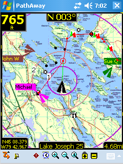
Send your current GPS location to another user or remote tracking service via SMS or Http protocol. See PathAway Send/Receive Format document for the supported send formats. Send manually via command, or have location sent automatically based on preset intervals.
Retrieve Remote Locations
As new Remotes are retrieved, they are assigned a default background color for display on the map. This color can be modified by Editing the Remote Item Info. Remotes are tracked by their ID passed along with the location message. The Label for a remote can be modified by the user for easier on-screen identification.
Retrieval is achieved either when an SMS message containing location information is received, or via automatic or manual polling of an Http-based Tracking server.
For Servers that return timestamp information, PathAway will download only updated location information.
On-Map Remote Labels:
- For each remote location being tracked, the tag on the map can display current location and heading of remotes, course, speed, elevation of remote, date/time of retrieval, distance to, course to, and elevation difference.
Calculate Location by Vector
Calculate a new Location by entering a distance and course from a starting location.
Available from Goto Location and Point Edit Location dialogs. Great for geocaching when you're provided only with a course and distance vector from your current location.
Directional Alarms
- In addition to the off-track and altitude warnings, turn instructions, and proximity notifications, PRO now offers different alarm sounds for left and right turns, left and right of off-track warning, and high and low elevation warnings.
Custom Alarms can trigger external programs
- Set the alarm sound in a Point to "EXEC <url or program name>" to have PathAway launch a special program or call up a Web Page when the proximity to the point has been reached. Great for tour guide application.
Map Display
- Views of Distance Radials on Map. See View->Map Display... settings. Displays distance radials in predefined distance rings.
Find Location by Street Address Lookup: (Internet connectivity required)
Enter a street address, then choose from the closest points found. Choose whether to show the point on the map, add a new point, or navigate to the address location.
New Find Location Dialog
- New Find Location dialog is now a Wizard style to provide step-by-step assistance on finding the location you're looking for. Options include: select location by coordinates, Online Street Address lookup, Point database lookup, or start of track or route locate. Once found, choose whether to show the point on the map, add a new point, or navigate to the new point.
User Interface Improvements
- Added New UI Elements including Reorganized Menus. Optional Text-based tools option for one handed control. (See View->Text Menus). Switch directional arrows between Zoom map, Scroll map, select item on map, and select dashboard item.
- GPS Status added as a Dashboard option.
- "Show Note" to Point Context Menu. Displays note text of waypoint. Also, a 'T' icon will show on the Proximity Dash item. Click on the 'T' to show the waypoint Notes.
- Screens made square and widescreen aware.
- UI Screens now utilize Windows Mobile 5 command key buttons.
PathAway Map Manager
- Basic support added for OZIExplorer .map and .geo import. Currently supports multi-point calibration in "dd mm.mmm" format. Open the map by bitmap name (ie. map.jpg) and PathAway will look for an associated Map or .geo calibration file.
- Map Manager, support for PNG, GIF and TIF files.
Experimental Features:
PathAway PRO also includes some features that are not considered to be part of the commercial package, but are included for experimental and special interest purposes. They are included to encourage feedback from you, and to highlight some of the R&D that is being done at the PathAway Lab. Experimental features may or may not appear in future product releases. The following features are currently available for experimental purposes only.
Web Maps (Internet connection required)
Designed for Phone Edition Pocket PCs, Web Maps allows you to download maps on-the-fly from a Map Server. Maps will be downloaded in the background and displayed on the screen as they complete downloading. Maps are cached, so downloading only needs to be done once.
Currently supported map servers:
Google Maps: Worldwide street and satellite maps.
Terraserver-USA Maps: USGA Topographic and aeriel photo maps. Covers USA only.
|